Survey Numbers, Subdivisions & Administrative Structure
1. What is a Survey Number in Land Records?
Land Records in India: A survey number (also called S.No. or Survey No.) is a unique identifier assigned to a specific parcel of land by the government during an official land survey. Every distinct parcel of land within a revenue village receives its own survey number when revenue officials systematically survey and map the area. A survey number is unique only within a revenue village, not across a taluk, district, state, or country. The same survey number say, Survey No. 45 can and does exist in hundreds of different revenue villages across the state. To uniquely identify a piece of land at a broader administrative level, the survey number must always be combined with its village name (“Ur”), taluk, district, and state. For example, the complete unique reference would be: Survey No. 45/2A, Kovilpatti Village, Kovilpatti Taluk, Thoothukudi District, Tamil Nadu. This full hierarchy is what makes a land parcel truly unique across the country.
Purpose of a Survey Number
- Uniquely identifies a land parcel within a village / taluk
- Forms the basis for all legal and revenue records – patta, chitta, adangal, etc.
- Used in sale deeds, court documents, loan agreements, and government records
- Helps locate land on revenue maps (Tippan / FMB – Field Measurement Book)
2. How a Survey Number Gets Subdivided Over Time
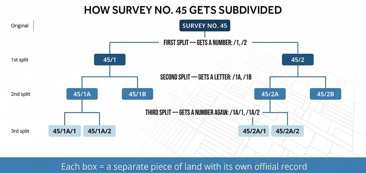
When land is partitioned due to sale, inheritance, court decree, or government acquisition, the survey number is subdivided. Each subdivision creates a new number derived from the parent. The original survey number is never deleted; it remains the root of all subsequent subdivisions.
Survey Number with Subdivision Example – Survey No. 45, Kovilpatti Village, Kovilpatti Taluk, Thoothukudi District, Tamil Nadu
What Each Survey Number Means – Step by Step
| Level | Example | What Happened |
|---|---|---|
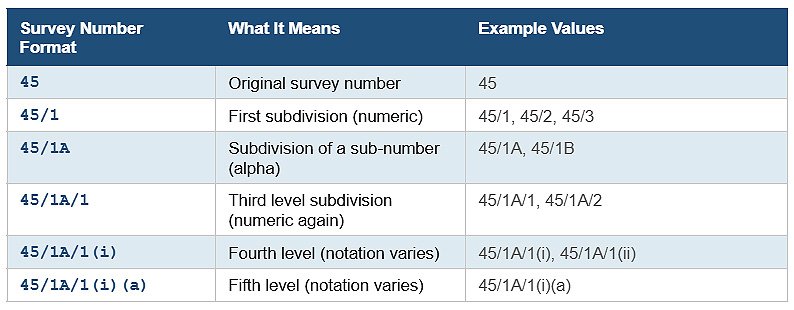
| Original | 45 | Original survey number as recorded in first government survey. |
| First split | 45/1, 45/2 | Land split into two parts — typically sale, inheritance, or partition. Numeric suffix added. |
| Second split | 45/1A, 45/1B, 45/2A, 45/2B |
Further split. Alphabetic suffix (A, B, C…) appended after the numeric sub-number. |
| Third split | 45/1A/1, 45/1A/2 | Third split. Numeric suffix restarts after the alphabetic component. |
| Fourth split | 45/2A/1(i), 45/2A/1(ii) |
Fourth split. Notation at this level varies across states and taluks. No single nationally standardised format exists beyond the third subdivision level. |
| Fifth split | 45/2A/1(i)(a), 45/2A/1(i)(b) |
Fifth split. Bracketed alphabets appended. Common in old urban family properties. |
Key Rules for Subdivision
- The original survey number (root) is never removed, it always exists as the parent identifier
- The total land area never changes during subdivision, it only gets divided. For example, if Survey No. 45 was originally 2 acres, and it is split into 45/1 and 45/2, those two pieces must together still measure exactly 2 acres. If 45/1 is further split into 45/1A and 45/1B, those two must together equal 45/1’s area. No land is created or lost, it is only shared differently
- Each subdivision gets its own FMB sketch, patta, and extent (area in hectares/acres)
- Multiple splits are most common in urban areas and old family properties divided across generations
- In Tamil Nadu, both the Sub-Registrar and the Revenue Department must stay in sync when a subdivision occurs
Survey Number Format Reference
As a survey number is subdivided over time, its notation follows a consistent pattern. Here is what each part of the number means:
- The first number (e.g. 45) is the original survey number assigned during the government’s first land survey of that village. It is the permanent root identifier and never changes, regardless of how many times the land is later subdivided.
- The number after the slash (e.g. 45/1, 45/2) is the first-level subdivision number, assigned the first time the original parcel is split. The first piece becomes /1, the second /2, and so on. On the Tamil Nadu government portal (eservices.tn.gov.in), this is entered as the Sub-Division Number field separately from the survey number.
- The letter after the sub-number (e.g. 45/1A, 45/1B) is assigned when a sub-divided piece is split again. Letters A, B, C are used at this level. In practice, real records in Tamil Nadu such as those viewable on the TN e-Services portal show subdivision numbers written as “2A” or “1B”, confirming this numeric-then-alpha pattern.
- Deeper subdivisions follow the same logic and continue alternating. However, in practice, most land records in Tamil Nadu remain at the first or second subdivision level (e.g. 45/1 or 45/1A). Subdivisions beyond two levels are uncommon and notation at those deeper levels may vary by taluk and the discretion of the revenue officer. The table below shows the commonly documented levels:
 Note: Each state may follow slightly different notation conventions. Tamil Nadu, Karnataka, and Maharashtra all differ slightly in deep subdivision notation. Document prepared for land records reference. Notation conventions may vary by state.