Chapter 1: Two Worlds of Land Records
Understanding TSLR, Town Survey Numbers, and How Land Gets Divided
Imagine Tamil Nadu as a giant jigsaw puzzle of land. Every single piece of that puzzle, whether it is a paddy field in a remote village or an apartment plot in the heart of Chennai, has a number assigned to it. That number is how the government keeps track of who owns what, how big it is, and what it is used for.
Tamil Nadu actually has two completely different systems of numbering land, depending on where that land is located.
Think of it like how your home address works differently in a village compared to a city. Land records work the same way. Rural land gets a Survey Number. Urban land inside a town or city gets a Town Survey Number, and its official record is called the TSLR Extract.
Both systems exist for the same reason: to give every piece of land a clear, traceable identity. They just operate through different offices and follow different rules.
Chapter 2: What is the TSLR Extract?
TSLR stands for Town Survey Land Register. It is the official record book maintained for plots of land that fall within the limits of a municipality, town panchayat, or corporation.
Think of the TSLR Extract as the land’s identity card in an urban setting. A rural plot has its Patta, which tells you the Survey Number, the owner’s name, and the extent of land. A city plot has its TSLR Extract. Both serve the same fundamental purpose: to officially declare who owns a piece of land and how much of it they own. The difference is which office issues it and which numbering system it uses.
A typical TSLR Extract contains the following information:
- The Town Survey Number (T.S. No.), which is the plot’s unique identity
- Ward Number and Block Number, which work like a postal address for the plot
- Extent of the land, usually measured in square feet or grounds
- The owner’s name, establishing who it legally belongs to
- Nature of land use, such as residential or commercial
- Any government claims or encumbrances on the land
One important distinction is worth noting here. A rural Patta comes with two companion documents: Chitta, which records ownership, and Adangal, which is the village land register maintained by the Village Administrative Officer (VAO). The Adangal captures agricultural details like the type of crop grown, the nature of the land (wet or dry), and cultivation patterns. All of that is rooted in farming. For an urban TSLR Extract, there is no Adangal equivalent and none is needed. City plots have no cultivation, no cropping seasons, and no VAO maintaining village records. All the relevant details about ownership, extent, and land use are recorded directly within the TSLR Extract itself.
This document is issued by the Town Survey Office, which works under the Survey and Settlement Department of Tamil Nadu.
Chapter 3: The Town Survey Number and Its Uniqueness
Every plot of land within a town survey area gets its own T.S. Number. But it does not stand alone. It always comes with a Ward Number and a Block Number, forming a three-part address for the plot.
Ward No. / Block No. / T.S. No. for example: Ward 5 / Block 12 / T.S. No. 234
The Ward is the neighbourhood or zone of a city. The Block is a cluster of plots within that neighbourhood. The T.S. Number is the specific plot within that block. When you see Ward 5, Block 12, T.S. No. 234 in a sale deed, you know exactly which piece of the city’s puzzle you are looking at.
Is the T.S. Number unique across Tamil Nadu?
This is an important question, and the answer is no, not on its own. The number 234 can exist in multiple towns and cities at the same time. What makes a plot truly unique is the full combination of four things together.
Town Name + Ward No. + Block No. + T.S. No. = Fully Unique Identity
T.S. No. 234 in Ward 5, Block 12 of Gummidipoondi is an entirely different plot from T.S. No. 234 in Ward 5, Block 12 of Tiruvottiyur. The town name is the crucial anchor that makes the number globally unique.
This is the same situation with rural Survey Numbers. A Survey Number is unique only within its revenue village boundary. Two different villages in the same district can both have a Survey No. 45/2A. In both systems, the geographic anchor, whether it is the town name or the village name, is what pins down the exact plot without any ambiguity.
Chapter 4: Rural vs Urban — How Are They Different?
Let us put the two systems side by side. Both exist to identify land, but they operate through entirely different mechanisms.
| What We Compare | Survey No. (Rural) | T.S. No. (Urban) |
| Where it applies | Villages and farmland | Towns and cities |
| Who manages it | Tahsildar / Revenue office | Town Survey / Survey Dept. |
| Main document | Patta (with Chitta & Adangal) | TSLR Extract |
| Number format | 45/2A (Survey/Subdivision) | 5/12/234 (Ward/Block/TS No.) |
| Uniqueness scope | Unique within a revenue village | Unique within a town’s Ward & Block |
| Land focus | Mostly agricultural | Residential / Commercial |
| Where to mutate | Taluk office | Town Survey / Corporation |
| Map document | FMB (Field Measurement Book) | Town Survey Sketch / Block Map |
The most important thing to remember is what happens when a village gets absorbed into a growing town. This happens frequently around cities like Chennai and Coimbatore. When that absorption happens, the land loses its old rural Survey Number and gets a brand new T.S. Number. The TSLR then becomes the governing document. This transition is a very common source of confusion for property buyers.
Chapter 5: The Story of a Plot That Gets Divided
Here is where the real drama begins. Imagine a large piece of land. Let us call it T.S. No. 234 in Ward 5, Block 12. It is a 10-ground plot owned by one family.
Over time, families grow. Land gets inherited, sold in parts, or split between siblings. Each time a piece of land is divided, it gets a new number, which is a subdivision of the original. This creates a trail of numbers that tells the complete history of that land.
Level 0 — The Original Plot
Our story begins here. The entire 10-ground plot is one undivided unit.
T.S. No. 234 (10 Grounds — undivided, owned by one family)
Level 1 — The First Split
The owner passes away and leaves the land to two children. The land is divided into two equal halves and each half gets its own number.
T.S. No. 234/1 (5 Grounds — Child A)
T.S. No. 234/2 (5 Grounds — Child B)
Level 2 — Going Deeper
Child A decides to sell half of their share to a buyer. The plot 234/1 now splits further.
T.S. No. 234/1/1 (2.5 Grounds — Child A keeps this)
T.S. No. 234/1/2 (2.5 Grounds — Sold to Buyer X)
T.S. No. 234/2 (5 Grounds — Child B, untouched so far)
Level 3 — Even Smaller
Buyer X further divides their 2.5-ground plot to sell to two different people.
T.S. No. 234/1/2/1 (1.25 Grounds — Sold to Person P)
T.S. No. 234/1/2/2 (1.25 Grounds — Sold to Person Q)
From one original plot numbered 234, we now have these active plots:
- 234/1/1, which is Child A’s remaining share
- 234/1/2/1, which belongs to Person P
- 234/1/2/2, which belongs to Person Q
- 234/2, which is Child B’s untouched share
Each of these has its own TSLR Extract. Every sale deed in this chain would mention the full lineage. For example, 234/1/2/1 would be described as a subdivision of 234/1/2, which was itself a subdivision of 234/1, originally part of T.S. No. 234. This lineage is how lawyers trace clean title before any property purchase.
Chapter 6: The Family Tree of a Plot
Here is a visual way to think about subdivision. The original plot sits at the top like a great-grandfather and each subdivision branches downward to its children and grandchildren. Notice how only one branch goes all the way to Level 3 while the others remain intact. In real life, not every branch divides at the same pace, just like in a real family.
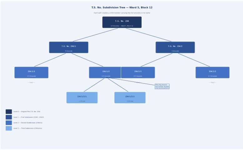
Figure: T.S. No. Subdivision Tree for Ward 5, Block 12. Darker shades represent older parent plots. Lighter shades are newer subdivisions.
Some plots stay whole for decades while others get subdivided multiple times. The tree keeps growing in an uneven, organic way depending on the decisions of each owner at each point in time.
Chapter 7: The Big Picture
Tamil Nadu’s land is divided into two worlds. In the villages, farmers and landowners deal with Survey Numbers and Pattas, managed by the Revenue Department and the Tahsildar. In towns and cities, property owners deal with Town Survey Numbers and TSLR Extracts, managed by the Town Survey Office under the Survey and Settlement Department.
Neither the rural Survey Number nor the urban T.S. Number is unique across the entire state on its own. A Survey Number is unique only within its revenue village boundary. A T.S. Number is unique only within its Ward and Block in a specific town. In both systems, you must always state the geographic anchor, either the village name or the town name, to identify a plot without ambiguity.
When a village grows into a town, its land undergoes a transformation. The old Survey Numbers retire and new Town Survey Numbers take their place. The TSLR becomes the new source of truth. This is why, when buying land in rapidly growing areas on the outskirts of cities, you must first determine whether the plot is still under a revenue village or has been absorbed into the town survey limits.
Within the urban TSLR world, land does not stay frozen. Families divide it, buyers buy pieces of it, and developers carve it up into layouts. Every time land is split, a new subdivision number is born, always carrying the history of its parent number in its name. A plot numbered 234/1/2/1 silently tells you its entire journey: it came from 234/1/2, which came from 234/1, which came from the original 234.
This chain of numbers is not just bureaucracy. It is the story of who owned the land, when they sold it, and how much they kept. For a property lawyer, reading a T.S. number chain is like reading a family history. For a buyer, verifying that chain all the way back to the original plot is what separates a safe purchase from a legal dispute waiting to happen.
Always check whether your property falls under a Survey Number or a Town Survey Number. That single question determines which documents you need, which office you visit, and how you trace the history of the land.
The land has a story. The numbers tell it.
Quick Reference Summary